Marine GPS


•Multifunction Navigation • Radar Scanners •

• Thermal Night Vision • Autopilot • 

•Radars •Fish Finder's • Satellite TV •


Having a GPS system on your boat that is up to date, and properly working is the safest way to boat on big lakes. Lake of the Ozarks has over 1100 miles of shoreline with length of 92 miles, at night most of the lake looks the same and you can get easily lost. We recommend you a trusted system that we have personally tested and use every day ourselves and currently install in boats just like yours.


We Carry Brands Like 


Garmin GPS Lake of the Ozarks

Raymarine GPS lake of the Ozarks

Garmin offers a full line of radome and open array radars.

Garmin xHD2 radars provide high-definition digital technology delivering high-resolution radar images to your plotter — images that are sharper with even better target separation. Garmin high-definition xHD2 antennas are the future-proof choice when upgrading your Garmin Marine Network.

Raymarine HD Colour and Super HD Open Array Scanners.

The choice of mid to large-sized powerboats and sailing vessels, open array radar scanners deliver higher sensitivity, better target detection and improved target separation. 

Garmin Marine Weather Proof Screens Come in 7inch all the way to 16inch!!!

Garmin Marine Chart Plotter Missouri Epic Audio

16-inch Multi-touch Widescreen Chartplotter/Sonar Combo

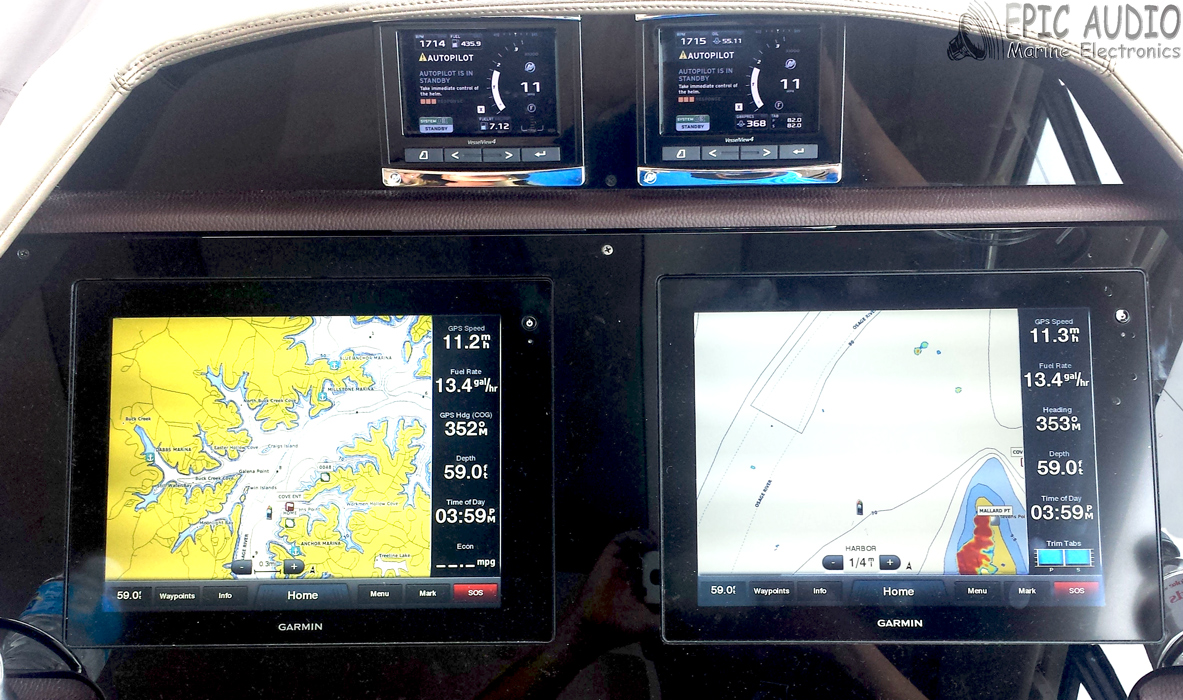
•16-inch multi-touch widescreen display (1366x768 WXGA) with worldwide basemap •Built-in dual CHIRP sonar plus CHIRP ClearVü and CHIRP SideVü scanning sonar with the clearest images on the water (transducer sold separately) •High-sensitivity internal 10 Hz GPS/GLONASS •Fully network capable for Garmin Marine Network and NMEA 2000®, plus NMEA 0183 support •Supports premium GSD™ sonar module Designed for sportsfishermen, cruisers, sailors and sailing racers who demand high performance, ease of operation, and feature integration in a chartplotter/sonar combo. The 16-inch multi-touch widescreen GPSMAP 7416xsv includes built-in dual CHIRP sonar plus CHIRP ClearVü and CHIRP SideVü scanning sonar with the clearest images on the water. Also supports 50 kHz/200 kHz, 77 kHz/200 kHz plus Minn Kota® and MotorGuide® trolling motor transducers. Internal 10 Hz GPS updates your position and heading 10 times per second. Fully network capable, including Garmin Network and NMEA 2000 (radar, autopilot, instruments, multiple screens, FUSION-Link, sensors, black box sonar, digital switching, thermal cameras, GRID and more), GPSMAP 7416xsv also offers the conveniences of built-in Wi-Fi® connectivity.
GPSMAP® 7416xsv

Garmin Marine Weather Proof Screens Come in 7inch all the way to 16inch!!!

Garmin Marine Chart Plotter Missouri Epic Audio
GPSMAP® 7416xsv Chart Plotter Missouri

8-inch Multi-touch Widescreen Chartplotter/Sonar Combo

•8-inch multi-touch widescreen display (1024 x 600 WSVGA) with worldwide basemap
•Built-in dual CHIRP sonar plus CHIRP ClearVü and CHIRP SideVü scanning sonar with the clearest images on the water (transducer sold separately)
•High-sensitivity internal 10 Hz GPS/GLONASS
•Fully network capable for Garmin Marine Network and NMEA 2000®, plus NMEA 0183 support
•Supports GSD™ 26 professional sonar module

Designed for sportfishermen, cruisers, sailors and sailing racers who demand high performance, ease of operation and feature integration in a chartplotter/sonar combo. The 8-inch multi-touch widescreen GPSMAP 7408xsv combo includes built-in dual CHIRP sonar plus CHIRP ClearVü and CHIRP SideVü scanning sonar with the clearest images on the water. Its internal 10 Hz GPS updates your position and heading 10 times per second. GPSMAP 7408xsv is fully network capable, including Garmin Network and NMEA 2000, and offers the conveniences of built-in Wi-Fi® connectivity.

Epic Audio Is Available To Answer Your Questions About Chart Plotters and More